 When you press terrain or victory hexes button and then move the mouse pointer over the map object (city, river, ...), its name, coordinates, optionally flag are displayed as a label |
Low Countries
10.5.1940 - 8.6.1940
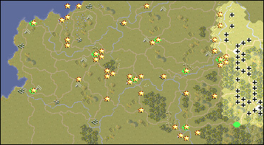
Scenario Map:
|
|
|
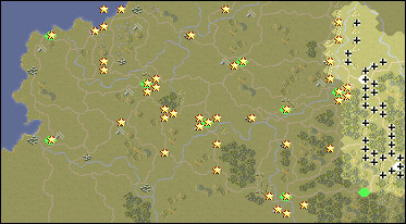
Original scenario map:
|
|
|
Scenario data:
| Version: PG, Starting side: Axis |
| Aachen Abbeville Airfield Amiens Arras Bittem Boulogne Brussels Calais Dunkirk Escout River Ghent Givet Hirshon Charleroi Leie River Liege Lille Luxembourg Mastricht Maubeuge Meuse River Namur Noyon Ostend Roer River Sambre River Sedan Somme River St. Quentin St. Valery Ypres |
| Aachen Abbeville Airfield Amiens Arras Bittem (correctly Bitburg) Boulogne (correctly Boulogne-sur-Mer) Brussels Calais Dunkirk Escout (correctly Scheldt River) Ghent Givet Hirshon (correctly Hirson) Charleroi Leie (correctly Leie River) Liege (correctly Liège) Lille Luxembourg Mastricht (correctly Maastricht) Maubeuge Meuse (correctly Meuse River) Namur Noyon Ostend Roer (correctly Roer River) Sambre (correctly Sambre River) Sedan Somme (correctly Somme River) St. Quentin St. Valery (correctly Saint-Valery-sur-Somme) Ypres |